Maiden Head, Addle Hill and Great Knightrider street, St Gregory by St Pauls EC4
St Gregory by St St Pauls pub history index
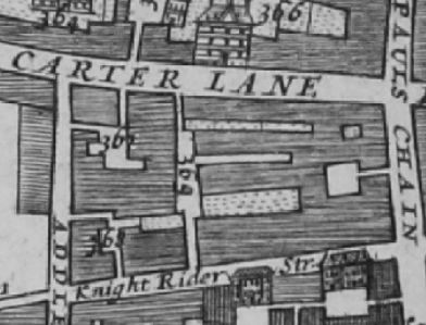
Great Carter Lane in 1682 Morgans Map of London lists 367 Mearmaid Inne ; 368 Maidenhead Inne and 369 Bell yard.
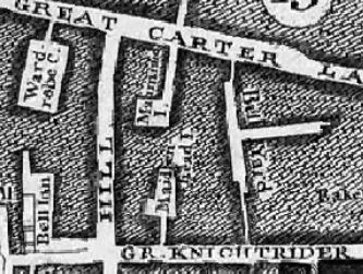
"Great Carter Lane in John Rocques 1746 Map marks the Mermaid Inn and the Maidenhead Inn.
A listing of historical London public houses, Taverns, Inns, Beer Houses and Hotels in St Andrew by Wardrobe parish, City of London.
Residents at this address.
The 1682 Morgans Map of London lists 367 Mearmaid Inne ; 368 Maidenhead Inne and 369 Bell yard.
In 1708 : A New View of London by Edward Hatton lists Maiden Head Inn, on the East side of Addle hill, near Great Carter lane.
John Strype Survey of London in 1720 - Farringdon Within Ward and Castle Baynard Ward lists and maps '71 Maiden head Inn'
The John Rocques 1746 Map shows Maidenhead Inn in Great Knightrider street, and no link to Addle hill.